Load in Precursor Coincident Dataset sites On-Demand#
coincident supports both reading into memory and downloading the Precursor Coincident Dataset (PCD) sites explained in https://coincident.readthedocs.io/en/latest/datasets
You can read in individual sites by memory given their PCD ID, or you can download the respective spatiotemporal metadata for ALL sites
from coincident import pcd_fixtures
import matplotlib.pyplot as plt
/home/docs/checkouts/readthedocs.org/user_builds/coincident/checkouts/104/src/coincident/io/download.py:27: TqdmExperimentalWarning: Using `tqdm.autonotebook.tqdm` in notebook mode. Use `tqdm.tqdm` instead to force console mode (e.g. in jupyter console)
  from tqdm.autonotebook import tqdm
pcd_fixtures.read_pcd_site?
Remember, our sites are below:
Provider |
PCD Site Identifier |
Description |
Fourway Overlap Area (km²) |
Aerial Lidar Start Date |
Aerial Lidar End Date |
|---|---|---|---|---|---|
USGS |
|
Urban over San Francisco |
55 |
2023-04-20 |
2023-04-20 |
USGS |
|
Desert / Mine in southern Arizona |
53 |
2021-09-27 |
2021-11-17 |
NEON |
|
Deciduous / Conifer in northern Utah |
25 |
2021-05-20 |
2021-05-21 |
USGS |
|
Cropland in eastern Nebraska |
540 |
2020-11-16 |
2020-12-09 |
USGS |
|
Urban / Wetlands in Green Bay, Wisconsin |
89 |
2020-05-07 |
2020-05-07 |
USGS |
|
Mixed LULC in southern Georgia |
745 |
2020-02-02 |
2020-03-28 |
NCALM |
|
Southern San Andreas fault line |
12 |
2020-02-15 |
2020-02-18 |
USGS |
|
Coniferous / Mountainous in northern Yosemite National Park |
84 |
2019-10-07 |
2019-10-23 |
USGS |
|
Shrubland / Grassland in western Texas |
165 |
2019-09-11 |
2019-10-20 |
NEON |
|
Mixed hardwood forest in eastern New Hampshire |
32 |
2019-08-25 |
2019-08-25 |
USGS |
|
Coniferous / Mountainous in the Colorado Rockies |
184 |
2019-08-21 |
2019-09-19 |
USGS |
|
Glaciers / Mountainous in western Wyoming |
681 |
2019-07-26 |
2019-09-22 |
NEON |
|
Conifer forest in southern Washington state |
18 |
2019-07-12 |
2019-07-15 |
Note
The NCALM site’s “ground truth” is not aerial lidar, but rather dense aerial SfM from a drone
%%time
dict_GA_Central_3_2019 = pcd_fixtures.read_pcd_site("GA_Central_3_2019")
CPU times: user 400 ms, sys: 74.9 ms, total: 474 ms
Wall time: 8.78 s
Note
Some sites take a longer time to read in than others (ranging from a few seconds to ~1 minute). This is mainly dependent on the overlap area and length of date range.
gf_als = dict_GA_Central_3_2019["als"]
gf_maxar = dict_GA_Central_3_2019["maxar"]
gf_is2 = dict_GA_Central_3_2019["is2"]
gf_gedi = dict_GA_Central_3_2019["gedi"]
gf_overlap = dict_GA_Central_3_2019["overlap"]
gf_als
| workunit | workunit_id | project | project_id | start_datetime | end_datetime | ql | spec | p_method | dem_gsd_meters | ... | seamless_category | seamless_reason | lpc_link | sourcedem_link | metadata_link | geometry | collection | datetime | dayofyear | duration | |
|---|---|---|---|---|---|---|---|---|---|---|---|---|---|---|---|---|---|---|---|---|---|
| 0 | GA_Central_3_2019 | 217457 | GA_Central_2019_B19 | 183179 | 2020-02-02 | 2020-03-28 | QL 2 | USGS Lidar Base Specification 1.3 | linear-mode lidar | 1.0 | ... | Meets | Meets 3DEP seamless DEM requirements | https://rockyweb.usgs.gov/vdelivery/Datasets/S... | http://prd-tnm.s3.amazonaws.com/index.html?pre... | http://prd-tnm.s3.amazonaws.com/index.html?pre... | MULTIPOLYGON (((-84.22648 31.22814, -84.21867 ... | 3DEP | 2020-02-29 12:00:00 | 60 | 55 |
1 rows × 33 columns
gf_maxar
| assets | bbox | collection | geometry | id | links | stac_extensions | stac_version | type | acquisition_rev_number | ... | utc_hour | utc_month_day | utc_time_of_day | view:azimuth | view:off_nadir | view:sun_azimuth | view:sun_elevation | view:sun_elevation_max | view:sun_elevation_min | dayofyear | |
|---|---|---|---|---|---|---|---|---|---|---|---|---|---|---|---|---|---|---|---|---|---|
| 0 | {'browse': {'href': 'https://api.maxar.com/dis... | {'xmin': -84.135038, 'ymin': 30.978549, 'xmax'... | wv02 | POLYGON ((-84.13481 31.95756, -84.13457 31.902... | 10300100A26FD700 | [{'href': 'https://api.maxar.com/discovery/v1/... | [https://stac-extensions.github.io/eo/v1.1.0/s... | 1.1.0 | Feature | 54250 | ... | 16 | 02-09 | 16:26:28 | 9.301677 | 25.749892 | 153.261732 | 39.779173 | 40.261337 | 39.292637 | 40 |
| 1 | {'browse': {'href': 'https://api.maxar.com/dis... | {'xmin': -84.124106, 'ymin': 30.989507, 'xmax'... | wv02 | POLYGON ((-84.12347 31.03196, -84.12349 30.989... | 10300100A132F900 | [{'href': 'https://api.maxar.com/discovery/v1/... | [https://stac-extensions.github.io/eo/v1.1.0/s... | 1.1.0 | Feature | 54250 | ... | 16 | 02-09 | 16:25:11 | 203.004258 | 10.248807 | 152.885173 | 39.687845 | 40.129383 | 39.177130 | 40 |
2 rows × 69 columns
gf_is2
| assets | bbox | collection | geometry | id | links | stac_extensions | stac_version | type | datetime | end_datetime | start_datetime | storage:schemes | dayofyear | |
|---|---|---|---|---|---|---|---|---|---|---|---|---|---|---|
| 0 | {'browse': {'href': 'https://data.nsidc.earthd... | {'xmin': -84.67409, 'ymin': 26.95991, 'xmax': ... | ATL03_006 | POLYGON ((-79.92487 59.53411, -80.14708 59.545... | ATL03_20200203102127_05910606_006_01.h5 | [{'href': 'https://cmr.earthdata.nasa.gov/clou... | [https://stac-extensions.github.io/storage/v2.... | 1.1.0 | Feature | 2020-02-03 10:21:26.442000+00:00 | 2020-02-03 10:29:56.914000+00:00 | 2020-02-03 10:21:26.442000+00:00 | {'aws': {'bucket': 'nsidc-cumulus-prod-protect... | 34 |
| 1 | {'browse': {'href': 'https://data.nsidc.earthd... | {'xmin': -88.23845, 'ymin': 26.95964, 'xmax': ... | ATL03_006 | POLYGON ((-88.01777 59.54564, -88.23845 59.534... | ATL03_20200316201642_12390602_006_01.h5 | [{'href': 'https://cmr.earthdata.nasa.gov/clou... | [https://stac-extensions.github.io/storage/v2.... | 1.1.0 | Feature | 2020-03-16 20:16:42.935000+00:00 | 2020-03-16 20:25:13.144000+00:00 | 2020-03-16 20:16:42.935000+00:00 | {'aws': {'bucket': 'nsidc-cumulus-prod-protect... | 76 |
gf_gedi
| assets | bbox | collection | geometry | id | links | stac_extensions | stac_version | type | datetime | end_datetime | start_datetime | storage:schemes | dayofyear | |
|---|---|---|---|---|---|---|---|---|---|---|---|---|---|---|
| 0 | {'002/GEDI02_A_2020040225749_O06582_03_T02744_... | {'xmin': -143.2615406, 'ymin': 0.4409358, 'xma... | GEDI02_A_002 | POLYGON ((-143.26111 51.77555, -137.28425 51.6... | GEDI02_A_2020040225749_O06582_03_T02744_02_003... | [{'href': 'https://cmr.earthdata.nasa.gov/stac... | [https://stac-extensions.github.io/storage/v2.... | 1.1.0 | Feature | 2020-02-09 22:57:49+00:00 | 2020-02-10 00:30:43+00:00 | 2020-02-09 22:57:49+00:00 | {'aws': {'bucket': 'lp-prod-protected', 'platf... | 40 |
| 1 | {'002/GEDI02_A_2020044212416_O06643_03_T05590_... | {'xmin': -143.1507574, 'ymin': 0.4364369, 'xma... | GEDI02_A_002 | POLYGON ((-143.1504 51.77648, -137.17463 51.64... | GEDI02_A_2020044212416_O06643_03_T05590_02_003... | [{'href': 'https://cmr.earthdata.nasa.gov/stac... | [https://stac-extensions.github.io/storage/v2.... | 1.1.0 | Feature | 2020-02-13 21:24:16+00:00 | 2020-02-13 22:57:10+00:00 | 2020-02-13 21:24:16+00:00 | {'aws': {'bucket': 'lp-prod-protected', 'platf... | 44 |
| 2 | {'002/GEDI02_A_2020048195041_O06704_03_T01321_... | {'xmin': -143.0124222, 'ymin': 0.406638, 'xmax... | GEDI02_A_002 | POLYGON ((-143.01216 51.777, -137.03573 51.636... | GEDI02_A_2020048195041_O06704_03_T01321_02_003... | [{'href': 'https://cmr.earthdata.nasa.gov/stac... | [https://stac-extensions.github.io/storage/v2.... | 1.1.0 | Feature | 2020-02-17 19:50:41+00:00 | 2020-02-17 21:23:34+00:00 | 2020-02-17 19:50:41+00:00 | {'aws': {'bucket': 'lp-prod-protected', 'platf... | 48 |
| 3 | {'002/GEDI02_A_2020052181703_O06765_03_T04320_... | {'xmin': -142.9432462, 'ymin': 0.4701104, 'xma... | GEDI02_A_002 | POLYGON ((-142.94325 52.0317, -136.9351 51.725... | GEDI02_A_2020052181703_O06765_03_T04320_02_003... | [{'href': 'https://cmr.earthdata.nasa.gov/stac... | [https://stac-extensions.github.io/storage/v2.... | 1.1.0 | Feature | 2020-02-21 18:17:03+00:00 | 2020-02-21 19:49:56+00:00 | 2020-02-21 18:17:03+00:00 | {'aws': {'bucket': 'lp-prod-protected', 'platf... | 52 |
| 4 | {'002/GEDI02_A_2020056164321_O06826_03_T04167_... | {'xmin': -142.921822, 'ymin': 0.3679382, 'xmax... | GEDI02_A_002 | POLYGON ((-142.92161 51.77505, -136.94421 51.6... | GEDI02_A_2020056164321_O06826_03_T04167_02_003... | [{'href': 'https://cmr.earthdata.nasa.gov/stac... | [https://stac-extensions.github.io/storage/v2.... | 1.1.0 | Feature | 2020-02-25 16:43:21+00:00 | 2020-02-25 18:16:15+00:00 | 2020-02-25 16:43:21+00:00 | {'aws': {'bucket': 'lp-prod-protected', 'platf... | 56 |
| 5 | {'002/GEDI02_A_2020060150939_O06887_03_T01474_... | {'xmin': -142.735739, 'ymin': 0.3123096, 'xmax... | GEDI02_A_002 | POLYGON ((-142.73138 51.57924, -136.77623 51.6... | GEDI02_A_2020060150939_O06887_03_T01474_02_003... | [{'href': 'https://cmr.earthdata.nasa.gov/stac... | [https://stac-extensions.github.io/storage/v2.... | 1.1.0 | Feature | 2020-02-29 15:09:39+00:00 | 2020-02-29 16:42:33+00:00 | 2020-02-29 15:09:39+00:00 | {'aws': {'bucket': 'lp-prod-protected', 'platf... | 60 |
| 6 | {'002/GEDI02_A_2020064133554_O06948_03_T04320_... | {'xmin': -142.6376625, 'ymin': 0.2937184, 'xma... | GEDI02_A_002 | POLYGON ((-142.63766 52.07815, -136.61871 51.8... | GEDI02_A_2020064133554_O06948_03_T04320_02_003... | [{'href': 'https://cmr.earthdata.nasa.gov/stac... | [https://stac-extensions.github.io/storage/v2.... | 1.1.0 | Feature | 2020-03-04 13:35:54+00:00 | 2020-03-04 15:08:47+00:00 | 2020-03-04 13:35:54+00:00 | {'aws': {'bucket': 'lp-prod-protected', 'platf... | 64 |
| 7 | {'002/GEDI02_A_2020068120206_O07009_03_T00051_... | {'xmin': -142.4574843, 'ymin': 0.2369259, 'xma... | GEDI02_A_002 | POLYGON ((-142.45748 51.77541, -136.47605 51.6... | GEDI02_A_2020068120206_O07009_03_T00051_02_003... | [{'href': 'https://cmr.earthdata.nasa.gov/stac... | [https://stac-extensions.github.io/storage/v2.... | 1.1.0 | Feature | 2020-03-08 12:02:06+00:00 | 2020-03-08 13:34:59+00:00 | 2020-03-08 12:02:06+00:00 | {'aws': {'bucket': 'lp-prod-protected', 'platf... | 68 |
| 8 | {'002/GEDI02_A_2020072102816_O07070_03_T00204_... | {'xmin': -142.2301645, 'ymin': 0.1814759, 'xma... | GEDI02_A_002 | POLYGON ((-142.23016 51.77553, -136.24741 51.6... | GEDI02_A_2020072102816_O07070_03_T00204_02_003... | [{'href': 'https://cmr.earthdata.nasa.gov/stac... | [https://stac-extensions.github.io/storage/v2.... | 1.1.0 | Feature | 2020-03-12 10:28:16+00:00 | 2020-03-12 12:01:09+00:00 | 2020-03-12 10:28:16+00:00 | {'aws': {'bucket': 'lp-prod-protected', 'platf... | 72 |
| 9 | {'002/GEDI02_A_2020076085423_O07131_03_T01780_... | {'xmin': -142.2077378, 'ymin': 0.2800325, 'xma... | GEDI02_A_002 | POLYGON ((-142.20767 51.77673, -136.22265 51.6... | GEDI02_A_2020076085423_O07131_03_T01780_02_003... | [{'href': 'https://cmr.earthdata.nasa.gov/stac... | [https://stac-extensions.github.io/storage/v2.... | 1.1.0 | Feature | 2020-03-16 08:54:23+00:00 | 2020-03-16 10:27:16+00:00 | 2020-03-16 08:54:23+00:00 | {'aws': {'bucket': 'lp-prod-protected', 'platf... | 76 |
| 10 | {'002/GEDI02_A_2020080072040_O07192_03_T03050_... | {'xmin': -142.2381634, 'ymin': 0.2677296, 'xma... | GEDI02_A_002 | POLYGON ((-142.23809 51.77522, -136.25606 51.6... | GEDI02_A_2020080072040_O07192_03_T03050_02_003... | [{'href': 'https://cmr.earthdata.nasa.gov/stac... | [https://stac-extensions.github.io/storage/v2.... | 1.1.0 | Feature | 2020-03-20 07:20:40+00:00 | 2020-03-20 08:53:34+00:00 | 2020-03-20 07:20:40+00:00 | {'aws': {'bucket': 'lp-prod-protected', 'platf... | 80 |
| 11 | {'002/GEDI02_A_2020084054801_O07253_03_T01627_... | {'xmin': -142.4382999, 'ymin': 0.2349711, 'xma... | GEDI02_A_002 | POLYGON ((-142.4383 52.12651, -136.40677 51.90... | GEDI02_A_2020084054801_O07253_03_T01627_02_003... | [{'href': 'https://cmr.earthdata.nasa.gov/stac... | [https://stac-extensions.github.io/storage/v2.... | 1.1.0 | Feature | 2020-03-24 05:48:01+00:00 | 2020-03-24 07:20:55+00:00 | 2020-03-24 05:48:01+00:00 | {'aws': {'bucket': 'lp-prod-protected', 'platf... | 84 |
| 12 | {'002/GEDI02_A_2020088041519_O07314_03_T02897_... | {'xmin': -142.6565891, 'ymin': 0.3032737, 'xma... | GEDI02_A_002 | POLYGON ((-142.65659 52.11351, -136.6275 51.84... | GEDI02_A_2020088041519_O07314_03_T02897_02_003... | [{'href': 'https://cmr.earthdata.nasa.gov/stac... | [https://stac-extensions.github.io/storage/v2.... | 1.1.0 | Feature | 2020-03-28 04:15:19+00:00 | 2020-03-28 05:48:14+00:00 | 2020-03-28 04:15:19+00:00 | {'aws': {'bucket': 'lp-prod-protected', 'platf... | 88 |
| 13 | {'002/GEDI02_A_2020092024236_O07375_03_T04167_... | {'xmin': -142.8046345, 'ymin': 0.2565015, 'xma... | GEDI02_A_002 | POLYGON ((-142.80445 51.77302, -136.81903 51.6... | GEDI02_A_2020092024236_O07375_03_T04167_02_003... | [{'href': 'https://cmr.earthdata.nasa.gov/stac... | [https://stac-extensions.github.io/storage/v2.... | 1.1.0 | Feature | 2020-04-01 02:42:36+00:00 | 2020-04-01 04:15:30+00:00 | 2020-04-01 02:42:36+00:00 | {'aws': {'bucket': 'lp-prod-protected', 'platf... | 92 |
gf_overlap
| pcd_id | geometry | |
|---|---|---|
| 0 | GA_Central_3_2019 | POLYGON ((-84.12672 31.01941, -84.1333 31.5686... |
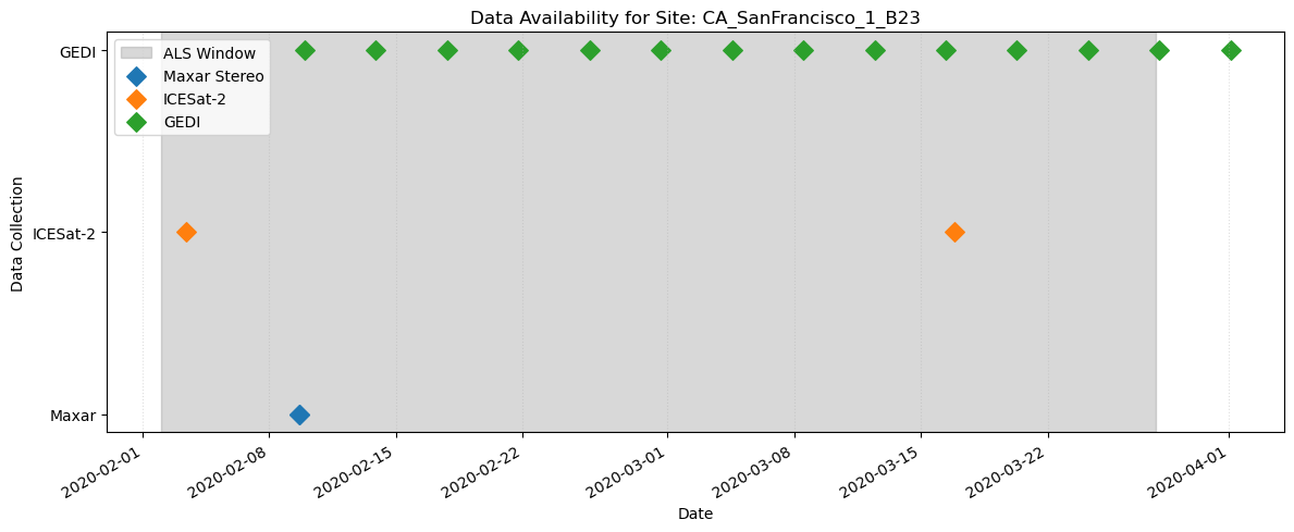
Visualize the acquisition times of the PCD site
fig, ax = plt.subplots(figsize=(12, 5))

als_start = gf_als["start_datetime"].iloc[0]
als_end = gf_als["end_datetime"].iloc[0]
ax.axvspan(als_start, als_end, color="gray", alpha=0.3, label="ALS Window")

ax.scatter(
    gf_maxar["datetime"],
    ["Maxar"] * len(gf_maxar),
    marker="D",
    s=80,
    label="Maxar Stereo",
)
ax.scatter(
    gf_is2["datetime"], ["ICESat-2"] * len(gf_is2), marker="D", s=80, label="ICESat-2"
)
ax.scatter(gf_gedi["datetime"], ["GEDI"] * len(gf_gedi), marker="D", s=80, label="GEDI")

ax.set_title("Data Availability for Site: CA_SanFrancisco_1_B23")
ax.set_xlabel("Date")
ax.set_ylabel("Data Collection")
ax.legend(loc="best")
ax.grid(axis="x", linestyle=":", alpha=0.4)
fig.autofmt_xdate()
plt.tight_layout();
See the spatial extent
style_args = {"fillOpacity": 0.15, "weight": 2.5}

m = gf_als.explore(
    name="ALS", color="gray", style_kwds=style_args, tiles="Esri.WorldImagery"
)
m = gf_maxar.explore(m=m, name="Maxar", color="blue", style_kwds=style_args)
m = gf_is2.explore(m=m, name="ICESat-2", color="orange", style_kwds=style_args)
m = gf_gedi.explore(m=m, name="GEDI", color="green", style_kwds=style_args)
m = gf_overlap.explore(m=m, name="Overlap Area", color="black", style_kwds=style_args)
m
Downloading#
You can also download the PCD files for all sites using the coincident.pcd_fixtures module. coincident.pcd_fixtures.download_pcd_files() supports this by streaming calls to the respective STAC catalogs and ALS endpoints.
Source code in coincident/scripts as seen below supports the downloading of the latest released GitHub assets of these PCD dataset files.
pixi run python src/coincident/scripts/generate_pcd.py
What’s the difference between the two?
coincident.pcd_fixtures.download_pcd_files() grabs the metadata for all PCD sites as provided by the respective STAC catalogs and API endpoints. src/coincident/scripts/generate_pcd.py pulls from the latest GitHub assets, which includes more complex overlap area geometries, LULC and elevation statistics over these geometries, and extended ALS metadata. The difference exists at the PCD sites from the latest GitHub assets have this extra metadata manually determined uniquely for each site (via reading individual lidar metadata reports, manually defining overlap geometries based on filtered data, using code that exists outside of coincident, etc.).
Because of this, running coincident.pcd_fixtures.download_pcd_files() will take minutes and running src/coincident/scripts/generate_pcd.py will take seconds.
pcd_fixtures.download_pcd_files?
# pcd_fixtures.download_pcd_files("/tmp")
Note
This takes ~4 minutes to run and the total output size for all files is 31mb (parquet files sum to ~8.5mb and geojsons sum to ~22mb)